Services
About the Parish
Information about the parish council
Hollowell and Teeton Parish Council, consisting of eight councillors and the clerk, meet bi-monthly at Hollowell Village Hall. The councillors are responsible for, among other things, the setting of the Parish precept and determining how the precept is spent throughout the year.
The Parish Council is responsible for various aspects of the Parish, including:
Mowing – the Parish Council contracts an external supplier to mow communal areas within the Parish. Please click for Parish Mowing Areas document for the latest maps.
Street lights – the Parish Council has recently undergone an extensive project to replace all streetlights within the Parish to more energy efficient models, to comply with legislation. The new models have also provided savings to the Parish through reduced energy consumption, therefore reduced energy bills. Please report any faults / extinguished street lamps to the Clerk quoting the location and lamp number, which can be found on the Parish Street Lighting Map by clicking on the link.
Rights of Way [Footpaths / Bridle Ways] – are not a direct responsibility of the Parish Council but Councillor Sue McCubbin undertakes maintaining liasion with the County Rights of Way Officer in regard to Rights of Way within the Parish. [Note Policy for RoW CY6 – The Jetty, Hollowell
Pocket Park – the Parish Council is responsible for the upkeep of the Pocket Park located on the Creaton Road in Hollowell, which includes mowing, maintenance of the trees and hedgerows, and maintenance of the play equipment. The latest playground inspection report can be requested from the Parish Clerk. The purchase of new equipment is organised by a group of local residents – see HPPAC page for further details.
Planning applications – any planning applications within the Parish will be discussed at a Parish Council meeting to determine our comments to West Northamptonshire Council. Details of the Village Design Statement can be found by clicking on the link and the latest planning applications can be found on the West Northamptonshire Council Planning Portal.
Grit Bins – these are provided and have been maintained by the County Council, however, Northamptonshire Highways notified the Parish Council (21/08/18) that two of the grit bins located on Church Hill, Hollowell, NN6 8RR would no longer be maintained and would be removed. Please contact the Council with your comments on this issue by emailing the Clerk (see details in letter on the link).
Parish Meetings
Annual Parish Meeting
The Annual Parish Meeting takes place each May to report on the activities in the Parish from the preceding 12 months. It is usually immediately followed by the Annual Parish Council Meeting.
Parish Council Meetings
Ordinary and Extraordinary Meetings
The Parish Council meets every other month for an Ordinary meeting, usually in Hollowell and Teeton Village Hall, Church Hill, Hollowell. NN6 8RR. The Council is occasionally summoned for Extraordinary meetings to discuss matters where a decision is required before the next scheduled Ordinary meeting.
Public Time
All Parish Council meetings are open for any members of the Parish to attend, and have scheduled Public Time where members of the Parish may speak for an allotted period of time on any of the issues on the agenda for that meeting.
Future Meetings
Future planned meeting dates for Ordinary meetings are as follows:
Annual Parish Meeting – 2026 TBC
Annual Meeting of the Parish Council – 2026 TBC
2026 (Wednesday)
18 March
20 May (Annual Meeting)
15 July
16 September
18 November
2027 (Wednesday)
20 January
17 March
History
Hollowell
Hollowell lies almost equidistant between the larger villages of Creaton and Guilsborough, one mile from the A5199, 9.5 miles north-west from Northampton.
The name Hollowell, originally Hollewelle, means the stream or spring in the hollow. It is listed in the Domesday survey of 1086 where a mill is mentioned. Several springs rose in the fields above the grounds of Hollowell Manor. These springs form a stream which goes underground at the Jetty and resurfaces in Home Farm Yard and then crosses the fields to join Stowe Brook.
The principal road structure through the village remains virtually unchanged since the 17th century and consists principally of three roads, Creaton Road, Guilsborough Hill and Church Hill which give the village its overall pattern in the shape of an irregular “Y”.
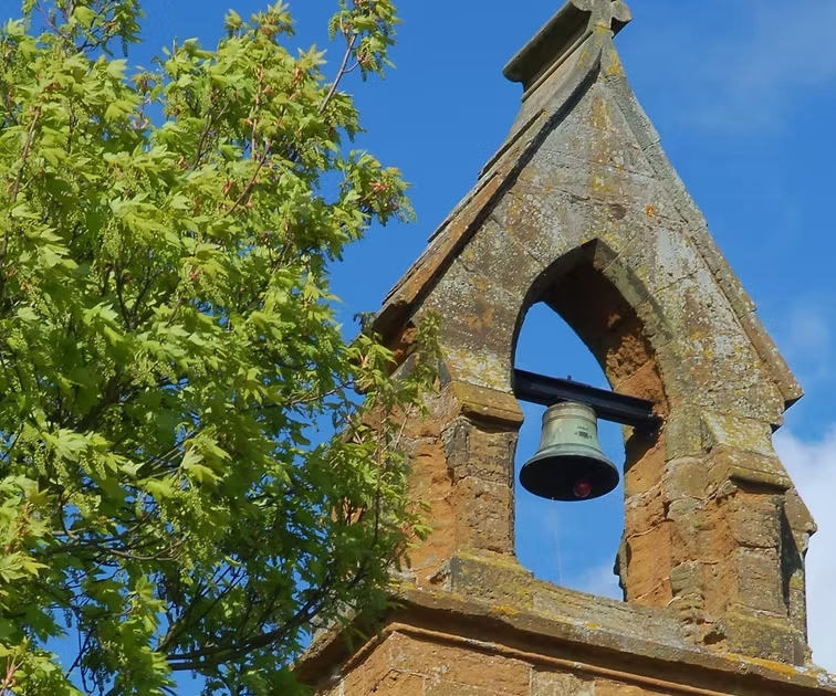
Approaching from Creaton off the A5199, the view of the village is outstanding, nestling in the valley of Stowe Brook with the reservoir bordering the north-east side and the church resting prominently on the west slopes. The bell tower, stone cross, east window and steep sloped roof can be seen clearly with the lower walls and churchyard sheltered from view by surrounding trees.
The character of the three main “arms” of the village are of mixed sizes and styles, with the variety ranging from the 17th century to the 21st Century and includes some dwellings that have been built on the site of older houses.
Always a small agricultural settlement, Hollowell’s population peaked in 1831 at 318 and by 1901 it had shrunk to 145. After this there was a steady climb to 353 in 2001(this figure includes the population of Teeton). In 2000 there were 115 households in Hollowell (including Highfield Park).
Hollowell reservoir was constructed on the Stowe Brook in the valley to the north east of the village. It was completed in 1938, is linked by a tunnel to Ravensthorpe reservoir and is a major landscape feature of the area.
Teeton
The origins of the name Teeton may signify its importance as a lookout or signalling point, for the land to the south west drops into a valley giving clear views all the way through to Northampton. In 1086 it was ‘Teche’ and in 1316 ‘Tetene’ from the saxon meaning ‘signal’ or ‘taecne’ meaning ‘beacon’.
It was always recorded as a hamlet within the parish of Ravensthorpe but in 1933 Northamptonshire County Council proposed that Teeton be joined to Hollowell Parish Council and this was done in 1936. It is believed that Teeton Mill was entered in the Domesday survey as Holdenby Mill, but references are made to Teeton Mill in 1619, 1672 and 1718. Reference – Geoffrey H. Starmer ‘A List of Northamptonshire Wind and Water Mills’
A small mainly farming community, Teeton maintained steady population figures of around 100 for many years. In the mid to late 19th century the population was accommodated in 23 houses. At the beginning of the 20th century, Teeton consisted of approx 10 houses.
Lying south west of Hollowell it is believed that the settlement of Teeton was formed as an estate for Teeton Hall. The Church Rooms (Chapel), The Mill and the public house still survive and have now been converted with some minor additions into three residences.
Three narrow roads from the east, south and west meet in the centre of Teeton at the entrance to Teeton Hall to form the principle area of the settlement. Dwellings are of mixed sizes and styles with the variety ranging from the 17th to 20th century. During the 19th and 20th centuries, the farm labourers’ cottages, farm houses, the mill and farm land were slowly sold off. And as a consequence the hamlet moved from a ‘self supporting’ community focussed on providing labour and provisions for the estates owner to a collection of houses in open countryside.
Asset Mapping Project
A small group of Councillors are undertaking a project as part of a working party to map assets within the Parish.
Terms of Reference for this working party can be found in the link below
Working Group Terms of Reference
Further details of the Asset Mapping Project can be found on the NCALC website.